IdeaMapSudan
The Aim
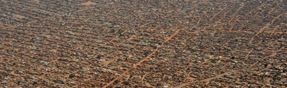
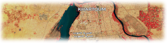
The aim of IdeaMapSudan is to develop a community-led geo-spatial database for mapping deprived urban areas (e.g., informal settlements) that will support the decision making process for displacement socio-economic reconstruction in Khartoum, Sudan. In Nov 2019, SUDTT organized a workshop under the title: Climate Change Security, Conflict and Displacement with the participation of 30 representatives from national bodies, local and international NGOs, research and academia. The workshop identified a clear gap in spatial information about the physical location and structure of deprived areas in Khartoum while also linking it to the socio-economic and socio-cultural issues within these areas. The need was identified for capacity building within the ministries dealing with these issues and also within relevant civil society organisations and NGOs. The identified capacity gaps can be traced throughout all the links of the chain that constitutes a complete information system. These are:
- lack of spatial data creation and collection
- lack of data management and analysis
- lack of the ability to translate spatial data into relevant policy
The Data Ecosytem
IdeaMapSudan will work collaboratively with local governments and civil society organisations, providing training on the use of digital maps produced from satellite imagery to map urban deprived areas /informal settlements, and link the geospatial data collected with community-based data and data from capacity and vulnerability assessments, creating an understanding of displacement challenges and opportunities associated with urban development and socio-economic reconstruction reforms in Sudan.
The Training
The training will focus on building the capacity to co-create and use spatial data on deprived areas (informal settlements). The training proposed will help to frame an ‘Integrated Deprivation Area Mapping System’, that is essential for developing a comprehensive roadmap for resilient and sustainable urban planning strategies for durable solutions to displacement in the Horn of Africa in general, and Sudan in particular. The training is provided by the Faculty of Geo-Information Science and Earth Observation of the University of Twente (ITC), the African population & health research centre (APHRC), and Université Libre de Bruxelles (ULB). This project is part of the Orange Knowledge Program (OKP) funded by the Dutch Ministry of Foreign Affairs and managed by Nuffic.
News and Updates
Register for the IdeaMapSudan Symposium (20-23 Feb. 2023)
Register for the IdeaMapSudan Public Lectures (23 Feb. 2023)
Visit our main project website: https://www.idea-maps.net
Contact: m.kuffer@utwente.nl